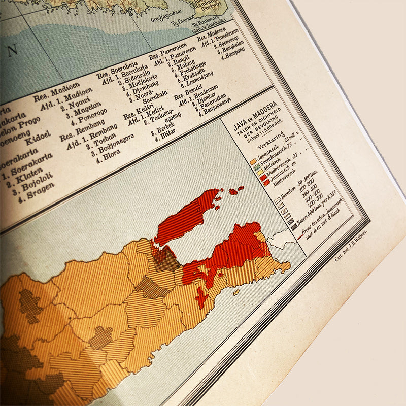
Map, Java – Dutch East Indies / Indonesia, J.B. Wolters – Groningen, The Netherlands, 1927
Map, Java – Dutch East Indies / Indonesia, J.B. Wolters – Groningen, The Netherlands, 1927
Details
Java 1:1.5 million; geological, land cover, city maps, languages, population density. Originally from: “Schoolatlas der geheele aarde”. First published in 1877. 31st edition, from 1927. By J.B. Wolters – Groningen, The Netherlands. Geographical survey maps (scale < 1:500,000), education, atlases, world atlases (form), teaching aids (form), cartography.
Size: ± 37 x 75 cm.
More information
Instead of Java cut in two, there is now a large fold-out map of that island on the same scale. The boundaries of the new province of West Java are marked on it; it is divided into nine residences: Banten, Batavia, Buitenzorg, Krawang, West, Central and East Preanger, Indramajoe and Cheribon. The steam tram line from Cheribon to Semarang was developed into a railway. However, express services from Batavia to Surabaya will only run over it from 1929. The following subsidiary maps were added: a coloured geological map of Java, one for density of population cum language map, and an agricultural product map, while the city maps were renewed and also included on this sheet. From the tenth to the fourteenth edition, an agricultural map of Java was also included in the atlas, from the tenth to the thirteenth edition also a language map.
In Java, the following traditional colonial spellings were restored by the Government Decree of 1925: Cheribon, Bantam, Poerworedjo, Wonosobo, Soemenep, Probolinggo, Sidoardjo, Grissee, Bondowoso, Sitoebondo, Modjokerto, Ponorogo, Bodjonegoro and Kertosono.
On the city maps, the sawah signature has been changed, giving the maps a calmer look. They have also been updated: in Batavia, a new barracks has been built in Weltevreden west of Koningsplein, the new part of Gondangdia, already marked as built-up, has not yet been completed, while part of Menteng to the south is. The Salemba and Kramat districts have been further urbanised. The railway line between Tanah Abang and Salemba has received a more southerly parallel track (already built in 1918). East of the city, the Antjol airfield is indicated. Later, this will become the Kemajoran airfield. Near Tandjong Priok harbour, the planned indigenous development Pedjong Koran has been realised on a smaller scale, a Uniekampong has also been added, and instead of the former seaside resort Petit Trouville that was on this map until the 25th printing, the seaside resort Zandvoort is now included. The new Tandjong Priok station is now on the map as is the Radio Holland building to maintain wireless telegraph links.
New is the map of Semarang. It is the headquarters of the Dutch East Indies Railway Company (NISM), the rival of the State Railways. The Pontjol station belonged to the Semarang-Cheribon Steam Tram Company, the Central Station to the Semarang-Joana Steam Tram Company. NISM's railway to the Vorstenlanden left from the north of the city, near the harbour, where the railway workshops were also located. On the site of the racecourse was once the Prince of Orange fort, which had sunk into the mud. To the west and east of the city, canals had been built for quick drainage during floods, the bandjir canals. On the map of Surabaya, nothing appears to have come of the planned urban expansion near the harbour. However, the harbour expansion itself was realised, both west and east of the Kali Mas, where the naval establishment was expanded. Necessary railway lines were constructed to open up Tandjoeng Perak harbour. Fort Prins Hendrik has been dismantled, as have the lunettes west of the city. The Post Station in the centre belongs to the State Railways; the station at Tambakdoekoeh belongs to the NISM. At Goebeng station, the two companies connect. The fishpond signature has been replaced by a swamp signature, and there is a new port development at Kali Anak in that area. The petroleum refinery at Wonokromo falls just out of the picture.
Java's agricultural map shows sawahs (irrigated rice fields), djati forests (teak), wildwood forests and clappers (coconut).
Java's geological map now also shows minerals: oil (near Tjepoe), iodine (Brantas Delta), sulphur (near volcanoes in the Preanger), gold (Southwest Preanger) and manganese (Kedoe). There are more than 20 working volcanoes on the island.
Condition: D • Fair condition. This item displays noticeable wear but is still presentable.
Couldn't load pickup availability
Condition guide
Condition guide
Our guide for grading, unless stated otherwise in the product description, is:
A • Mint condition. This items has almost no sign of use or handling.
B • Near Mint condition. Some signs of use.
C • Fine condition.
D • Fair condition. This item displays noticeable wear but is still presentable.
E • Poor condition. The item shows noticeable wear which is distracting; but this item is unique in some way.
Questions before ordering an item?
Please don't hesitate to contact us about any item you've found in our collection. We're happy to provide more pictures and or a video and if we can we are here to provide you with some more background information about an item.
Get in touch and add the link to the item you need more information about.
Questions
Questions
Any questions about this item? Please don't hesitate to contact us! When you do, please add the link to this page in your request. Get in touch.
Local pickup (Netherlands only)
Local pickup (Netherlands only)
Customers in the Netherlands can pick up their order(s) at different warehouses. Please get in touch to arrange a pick-up.
Delivery
Delivery
Special requests about personal delivery of the item(s) you're interested in? Please get in touch.
We'll send your order with PostNL, the number one parcel service in The Netherlands, delivering worldwide. More information is to be found in our Shipping policy.


